The rapid advancement of drone technology has transformed how industries collect, analyze, and interpret spatial data. From infrastructure planning to agriculture and mining, drones now play a critical role in turning raw aerial images into meaningful insights. At the heart of this transformation lies drone survey data processing, a crucial step that enables accurate mapping, measurement, and analysis through a photogrammetry drone survey.

Understanding Drone-Based Surveys
Drone-based surveys involve capturing high-resolution aerial images using unmanned aerial vehicles equipped with advanced sensors and cameras. These images are collected following precise flight paths to ensure adequate overlap and coverage. However, the true value of a drone survey is realized only after the captured data is processed and analyzed effectively.
This is where drone survey data processing becomes essential. It converts raw imagery into usable outputs such as orthomosaic maps, digital elevation models (DEMs), point clouds, and 3D models.
What Is Photogrammetry Drone Survey?
A photogrammetry drone survey uses overlapping aerial photographs to extract accurate measurements and spatial information. By analyzing multiple images of the same area from different angles, photogrammetry software reconstructs the terrain or structures in three dimensions.
This method is widely used because it offers:
- High accuracy and resolution
- Faster data collection compared to traditional surveys
- Cost-effective mapping for large or inaccessible areas
When combined with robust data processing workflows, photogrammetry delivers precise and actionable insights.
The Importance of Drone Survey Data Processing
Capturing images is only the first step. Without proper processing, raw drone data remains incomplete and unreliable. Drone survey data processing ensures that images are aligned, corrected, and converted into accurate geospatial products.
Key objectives of data processing include:
- Removing distortions caused by camera angle or terrain
- Aligning images using ground control points (GCPs)
- Generating accurate spatial coordinates
- Producing consistent and measurable outputs
Efficient processing directly impacts the accuracy and reliability of the final survey results.
Key Stages of Drone Survey Data Processing
Image Alignment and Calibration
The first stage involves aligning thousands of images captured during the flight. Advanced algorithms identify common points across images and stitch them together. Camera calibration ensures that lens distortions are corrected, creating a consistent base for further analysis.
Point Cloud Generation
Once images are aligned, the software generates a dense point cloud. This cloud represents millions of data points in 3D space, forming the foundation of any photogrammetry drone survey. Each point contains precise X, Y, and Z coordinates.
Surface and Terrain Modeling
From the point cloud, digital surface models (DSM) and digital terrain models (DTM) are created. These models help identify elevation changes, slopes, and surface features, which are critical for engineering, mining, and environmental applications.
Orthomosaic Creation
Orthomosaics are high-resolution, georeferenced images created by stitching multiple photos together. Unlike regular aerial photos, orthomosaics are corrected for scale and distortion, making them suitable for accurate measurements and analysis.
Applications Across Industries
The combination of drone survey data processing and photogrammetry drone survey supports a wide range of industries:
Infrastructure and Construction
Engineers use processed drone data for site planning, progress monitoring, and volumetric calculations. Accurate 3D models help reduce errors and improve decision-making throughout the project lifecycle.
Mining and Quarrying
Drone surveys enable precise stockpile measurement, pit mapping, and safety monitoring. Processed data provides reliable volume calculations without disrupting operations.
Agriculture and Land Management
Farmers and agronomists benefit from drone-based mapping to assess crop health, irrigation patterns, and land conditions. Data-driven insights improve yield and resource efficiency.
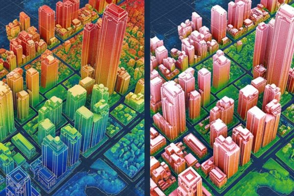
Urban Planning and Smart Cities
Urban planners rely on photogrammetry models to analyze land use, infrastructure expansion, and environmental impact. Drones offer a fast and scalable solution for city-level mapping.
Accuracy and Quality Control in Photogrammetry
Accuracy is a defining advantage of drone surveys when data is processed correctly. Ground control points, RTK/PPK systems, and validation checks ensure survey-grade results. High-quality drone survey data processing minimizes errors and improves confidence in measurements derived from a photogrammetry drone survey.
Quality control steps often include:
- Cross-checking coordinates with ground references
- Reviewing overlap and coverage
- Verifying model consistency
Advantages Over Traditional Survey Methods
Compared to conventional surveying techniques, drone-based photogrammetry offers:
- Faster turnaround times
- Reduced manpower and field risks
- Greater coverage in less time
- Highly detailed visual and spatial data
These benefits make drone surveys an increasingly preferred solution for modern data collection and analysis.

Future of Drone Survey Data Processing
As software algorithms and AI-driven tools continue to evolve, drone survey data processing is becoming more automated and efficient. Machine learning is improving feature extraction, object detection, and data interpretation, further enhancing the value of photogrammetry drone survey solutions.
Cloud-based platforms are also enabling faster processing and easier collaboration, making drone data more accessible to stakeholders.
Conclusion
Transforming aerial images into meaningful insights requires more than just advanced drones—it demands accurate processing, skilled analysis, and reliable workflows. By combining robust drone survey data processing techniques with a precise photogrammetry drone survey, organizations can achieve unparalleled accuracy, efficiency, and clarity in spatial data analysis. Industry leaders such as Asteria Aerospace continue to play a vital role in advancing drone-based surveying solutions, helping businesses unlock the full potential of aerial intelligence.


